Australian (ASX) Stock Market Forum

Cyclones imminent in North Queensland

Garpal Gumnut

Ross Island Hotel
Joined
2 January 2006
Posts
13,795
Reactions
10,568
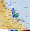
Without trying to take away from the pain experienced in the Lockyer Valley, Toowoomba, and Brisbane, all predictions are on for a series of massive cyclones in North Queensland in the coming 2-12 weeks.

From

www.bom.gov.au

Tropical Cyclone 3-day outlook for The Coral Sea

IDQ10810
Australian Government Bureau of Meteorology
Brisbane

Tropical Cyclone 3-day outlook for The Coral Sea
Issued at 2:37pm EST on Friday the 21st of January 2011 and valid until end of
Monday

Existing Cyclones in the Eastern Region:
Nil.

Potential Cyclones:
The monsoon trough remains active across north Queensland and the northern Coral
Sea. A low situated over north Queensland is likely to move into the Coral Sea
while the monsoon trough strengthens over the next couple days.

Saturday: Low
Sunday: Moderate
Monday: Moderate

NOTE: The likelihood is an estimate of the chance of each system being a
tropical cyclone in the Region for each day.
Very low: less than 5% Low: 5% - 20%
Moderate: 20% - 50% High: Over 50%

The area of coverage for this outlook is the Coral Sea and Northern Tasman Sea
west of 160E.

Further information on Tropical Cyclones is available at:
http://www.bom.gov.au/weather/cyclone

gg
 
this is bad ... and certainly any cyclone activity in the north of queensland couldnt come at worse time.

hopefully the worst of it can stay in the coral sea and not come towards the east coast.

But they said 1893 was 2 seperate 8m floods in the same summer, history repeats ?
 
this is bad ... and certainly any cyclone activity in the north of queensland couldnt come at worse time.

hopefully the worst of it can stay in the coral sea and not come towards the east coast.

But they said 1893 was 2 seperate 8m floods in the same summer, history repeats ?

Hi
I am near Daintree and it has rained steadily most of the last 16 hrs. temporily stopped.
But it appears to be monsoon rain. I have family inland and raining there as well.(but steady).
Cheers
 
Let's hope this one just dies off and goes away, it could be the last straw for many in Agriculture up this way.

IDQ65001.gif


gg
 
Let's hope this one just dies off and goes away, it could be the last straw for many in Agriculture up this way.

IDQ65001.gif


gg

great informative post GG. being a north queensland lad myself, i witnessed panick bying woolworths style last night when i needed some things.

Now like GG said, trust us cyclone/rain/wind - QLD dont need any more, qld needs hope.

jc
 
Thinking of all of you up there in FNQ. Hope it turns tail in fear of you and goes back out to sea.
 
Expected as a catagory 2 when it hits the coast, it's towards the lower end of the intensity scale. Standard fare for that part of the world in terms of tropical cyclones.

The one modelled for mid/late in the week is potentially of far greater scale.
 

Attachments

  • Wind3285032and32mslp_Australia_96.gif
    Wind3285032and32mslp_Australia_96.gif
    53 KB · Views: 112
great informative post GG. being a north queensland lad myself, i witnessed panick bying woolworths style last night when i needed some things.

Now like GG said, trust us cyclone/rain/wind - QLD dont need any more, qld needs hope.

jc

Thinking of all of you up there in FNQ. Hope it turns tail in fear of you and goes back out to sea.

Thanks jc and Julia,

Expected as a catagory 2 when it hits the coast, it's towards the lower end of the intensity scale. Standard fare for that part of the world in terms of tropical cyclones.

The one modelled for mid/late in the week is potentially of far greater scale.

Agree, it sounds like a whopper!.

gg
 
Thinking of all of you up there in FNQ. Hope it turns tail in fear of you and goes back out to sea.

This +1. People up there do it very tough in general, they seem like there constantly year after year bombarded with weather like this. It would be nice if the wheather gave them a reprieve every now and then.
 
Agree, it sounds like a whopper!.

gg
If that numerical weather model is correct, that system will take the monsoon inland with it bringing another burst of heavy rain to the interior and possibly, large parts of southeastern Australia.

The super La-Nina of 2010/11 is far from finished with us yet.
 
TC Yasi is a massive system that's for sure. Certainly dwarfs present TC Anthony below.
 

Attachments

  • untitled.jpg
    untitled.jpg
    106.9 KB · Views: 423
This +1. People up there do it very tough in general, they seem like there constantly year after year bombarded with weather like this. It would be nice if the wheather gave them a reprieve every now and then.
That's so true. It's a point Bob Katter made on the 7.30 Report recently when he was arguing for a permanent disaster fund. He says, quite correctly, that up to now FNQ has been left to pretty much fend for itself amongst cyclones and floods, and only now that the capital city of Brisbane has been affected is there any actual concern shown by State and Federal governments. He makes a very good case for a permanent fund to be set up. If it ever happens, I'd hope there will be some very strong safeguards to prevent it being siphoned into consolidated revenue whenever the profligate feds run out of bribe money next.
 
This thing has high potential to not only blow stuff over but dump half the Pacific Ocean in Queensland. Cloud mass covers about 1/4 of Queensland alone.
 

Attachments

  • gms_ir.gif
    gms_ir.gif
    157.3 KB · Views: 121
Top