Australian (ASX) Stock Market Forum

Cyclones imminent in North Queensland

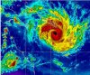
It's like something out of hell, and it's heading straight for Central Queensland and is due on Wednesday.

http://www.goes.noaa.gov/sohemi/sohemiloops/shirgmscol.html

Wow, that's a frightening looking mass. We phoned our insurance today even though we are not likely to be in it's path here on the Gold coast as we wanted to double check our flood cover and aware that these nasties can change direction. Apparently we aren't the only ones phoning - they are inundated with similar calls due to the fear of TC Yasi.
 
I don't know what to say. Yasi is huge. I can only hope that this thing peters out in the ocean, because if it doesn't and stays on the current predicted course, well...my house is only an old timber and fibro.
 

Attachments

  • yasi.jpg
    yasi.jpg
    119.1 KB · Views: 63
That's one nasty looking beast.


Looks like it's at least 3/4 of the QLD coastline in this one :eek:


I'd agree mate, if any cyclone in memory has the chance to wipe out the Ross Island Hotel this mf Yasi has.

I have a distinct feeling of dread and discomfort.

gg
 
I'd agree mate, if any cyclone in memory has the chance to wipe out the Ross Island Hotel this mf Yasi has.

I have a distinct feeling of dread and discomfort.

gg

I bet you do mate, so would I quite frankly if I were up your way. Stay safe brother, and keep a hold of your hat. Looks like this one could take it all the way to the red centre.

Just flicked on the weather channel. They're saying there could be over a meter of rain and it's looking like it will be a cat 4-5 by the time it gets here. It's just never ending for you poor QLD'ers. Thinking of you all.
 
Very scary. gg and others in its likely trajectory: what preparations are you making?
Will you take off inland? Where we are is included in its periphery. There is no local cyclone rated shelter. It seems the best we can do is bunker down in our houses and hope.

But my main thought is with those of you further north far more likely to be in its direct path. It's one of those times I wish I were religious and then I could say "I'm praying for you."

Keep us posted as you are able.
 
Have no fear. You know it's just "weather". ;)

lol , weather kills though, climate is part of the decision making as to where you decide to holiday.

gg

Very scary. gg and others in its likely trajectory: what preparations are you making?
Will you take off inland? Where we are is included in its periphery. There is no local cyclone rated shelter. It seems the best we can do is bunker down in our houses and hope.

But my main thought is with those of you further north far more likely to be in its direct path. It's one of those times I wish I were religious and then I could say "I'm praying for you."

Keep us posted as you are able.

I think I'll stay in garpalhome. If we leave, its a bit like running away. We may be needed to help out after the blow. We also have some elderly neighbours who are staying put.

A few friends and pets coming to stay from flood prone areas.

Thanks for your concern. It could go anywhere though, so make sure you and puppy are safe.

gg
 
Good luck with sitting this cyclone out GG. It's not going to be a very nice experience.

I went through George which was of similar intensity, even though we have a D rated cyclone house, we still lost windows. So make sure you have a back up plan just in case something goes wrong. It's pretty fearful when the walls and windows start to bend and groan.
 
I think I'll stay in garpalhome. If we leave, its a bit like running away. We may be needed to help out after the blow. We also have some elderly neighbours who are staying put.
Latest warnings indicate landfall near Cairns so Townsville may be spared the worst.

That BoM threatmap (above) showing it just passing just north of Cairns would be the worst possible outcome for that location I imagine.

The Joint Typhoon Warning Centre (USA) currently estimates gusts to 150 knots (278 km/hr) just prior to crossing the coast (02/1200UTC). A Catagory 5 is gusts of 280km/hr and above.

http://www.usno.navy.mil/NOOC/nmfc-ph/RSS/jtwc/warnings/sh1111.gif

Once it crosses the coast, it's likely to persist over inland parts of the continent as a rain depression for several days.
 
I just want to draw people's attention to this site where you can access information and download some checklists to help you prepare and what to put in kits etc.
http://www.disaster.qld.gov.au/


The current forecast is for it to cross somewhat north of me, however because of the sheer size of it, we will still receive the equivalent of a category 2 cyclone.
 
I am in Port Douglas. Looks like its gunna get a bit windy here!

TCYasi1.gif

Overit, ABC Radio has just been broadcasting urgent requests for anyone in Port Douglas to evacuate now. Ditto low lying areas of Cairns.

So much thinking of you all up there. Hope you'll all stay safe.
 
lol , weather kills though, climate is part of the decision making as to where you decide to holiday.

gg


I think I'll stay in garpalhome. If we leave, its a bit like running away. We may be needed to help out after the blow. We also have some elderly neighbours who are staying put.

A few friends and pets coming to stay from flood prone areas.


Thanks for your concern. It could go anywhere though, so make sure you and puppy are safe.

gg


GG

Hope you are high and dry, just got this off the wires,

Residents in low-lying parts of Townsville urged to evacuate

Also just got this tweet @ the desk..
If your house becomes flooded in Townsville, the fish market can provide complimentary refrigerated storage to assist (0-5 deg cel.)
http://twitter.com/#!/TsvFishMarket/status/32408918806241280
 
Top